Kings Highway
Project Updates
General Update: A general public workshop was held on February 20, 2024 to present the proposed improvements to the community. The project has recently completed the preliminary design stage and is working towards the finalization of right-of-way needs.
Anticipated Schedule (subject to change)
- Kings Highway and Gills Neck Road Master Plan: September 2016 ✓
- Concept Design Initiated: August 2020 ✓
- Virtual Public Workshop: February 2022 ✓
- Concept Re-evaluation & Additional Studies: Spring 2022 – Fall 2022 ✓
- Independent Review: Fall 2022 – Spring 2023 ✓
- Concept Revisions: Spring 2023 – Summer 2023 ✓
- Additional Public Outreach: Summer 2023 – Fall 2023 ✓
- Public Workshop: February 20, 2024 ✓
- Preliminary Engineering: Winter 2024 – Fall 2024 ✓
- Begin ROW Acquisition: Spring 2025
- ROW Funding: FY 25 – FY 27
- Construction Funding: FY 28 – FY 31
Proposed Improvements
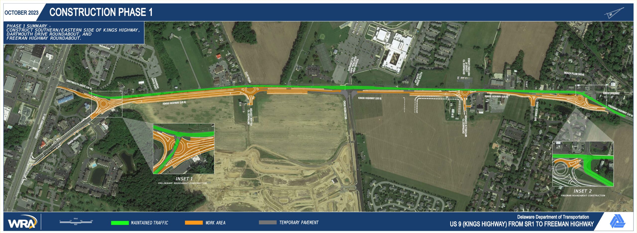
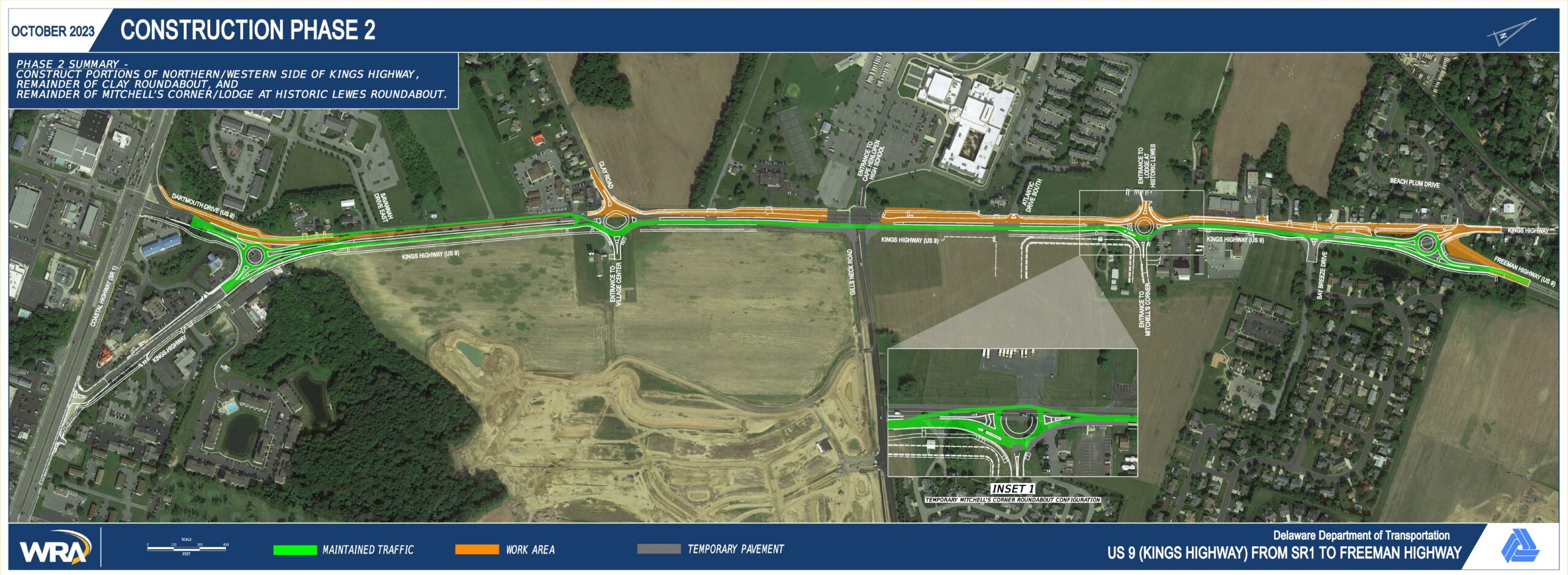
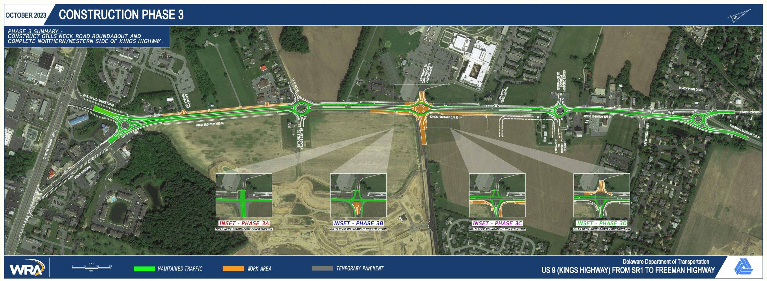
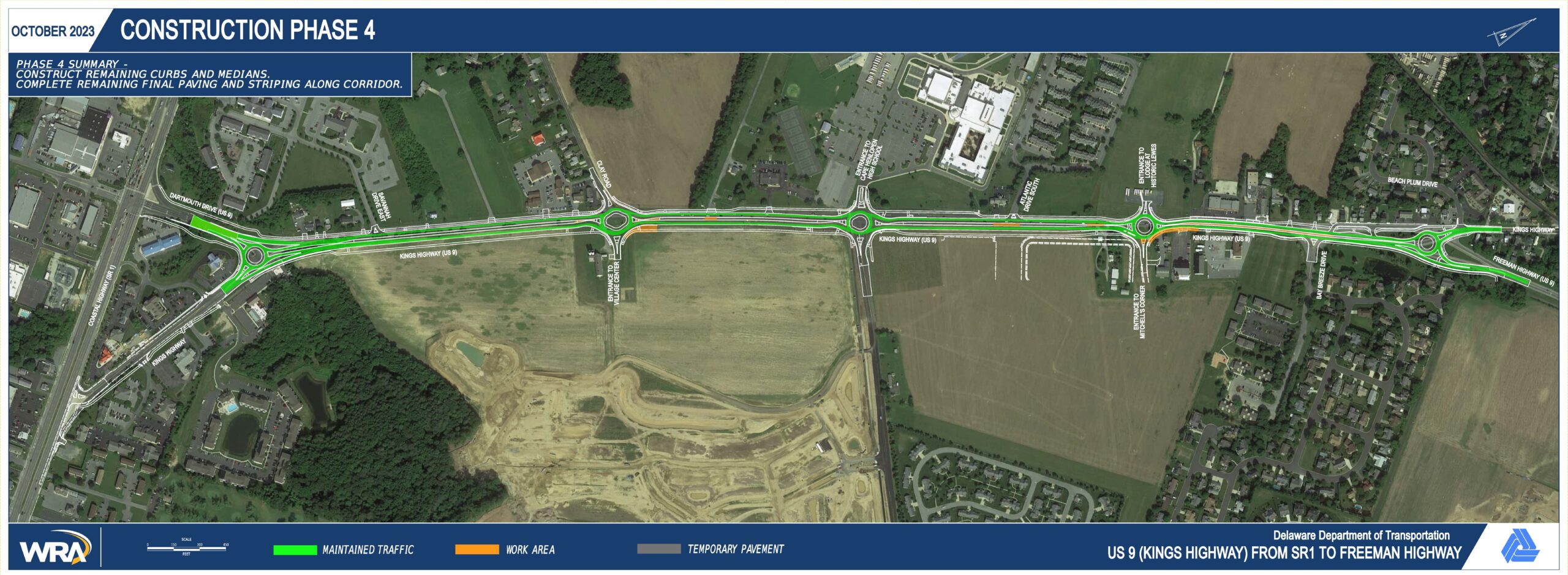
Construction Phasing
Phasing Summary: Construction will be completed in multiple phases in order to maintain traffic along Kings Highway and access to adjacent properties throughout construction. Roadway closures and associated detours will be required at times in select areas to complete portions of the project. Roadway closures will be scheduled to minimize duration and impact to the general public.
Conceptual Construction Phasing (subject to change)
Click Images to Enlarge
Phase 1
Phase 2
Phase 3
Phase 4
FAQ
Roundabouts
No. Traffic circles and rotaries are older circular intersection designs which involved large diameters, higher speeds, and signals or varying yield requirements at entry points. The modern roundabout is a smaller intersection design which encourages lower speeds and functions under the principle that entering traffic always yields to traffic already in the roundabout. While New Jersey has removed or modified several traffic circles in recent years, many have been converted to modern roundabouts. Several new roundabouts have also been constructed including the Morris Street & Spring Street intersection in Morristown, NJ, and the Valley Road & Great Notch Road in Clifton, NJ. Similarly, Pennsylvania, Maryland, Virginia, and states nationwide continue to construct new roundabouts as an effective intersection improvement alternative. Drivers should observe signs and pavement markings to select the correct lane prior to entering the roundabout. When first encountering the roundabout, approaching traffic always yields to traffic already in the roundabout as well as pedestrians and bicyclists within crosswalks. Once in the roundabout, drivers should follow pavement markings and signs to direct them towards their intended exit. Roundabouts are designated as a proven safety countermeasure by the Federal Highway Administration. Vehicles navigating a roundabout must do so at lower speeds and will encounter less points of conflict with other vehicles compared to a traditional signalized intersection. Roundabouts are especially adept at reducing right-angle, left-turn, and head-on collisions which represent the higher severity crash types with higher likelihood for serious injuries and fatalities. Yes, the roundabouts along Kings Highway are designed to accommodate many different vehicle types including buses, RVs, pickup trucks with camper/boat in tow, and interstate tractor trailers. A turning analysis is performed for each roundabout to ensure that larger vehicles can make the necessary movements. Each roundabout will include a slightly raised concrete truck apron within the central island which is intended for oversized vehicles to mount during certain movements. This design element allows for all vehicle types to navigate the roundabout while still maintaining a smaller footprint and reducing vehicle speeds. Overall, the increase in operational efficiency of the roundabouts will improve travel times along Kings Highway compared to other intersection configurations. While queues may be encountered approaching the roundabout, they generally exhibit a more continuously flowing pattern compared to a static queue waiting at a traffic signal. If an emergency vehicle is encountered along the corridor, drivers should move to the right prior to entering a roundabout and stop. If an emergency vehicle is encountered while navigating the roundabout, exit the roundabout then pull to the right to allow the emergency vehicle to pass, do not stop in the roundabout. Yes, there are numerous examples of roundabouts at or in close proximity to school entrances. Examples include St. James Academy Catholic High School in Lenexa, KS, St. Mary’s High School in Kitchener, Ontario, Bay Port High School in Green Bay, WI, Olentangy Orange High School in Lewis Center, OH, and Dublin Jerome High School in Dublin, OH. School officials from these high schools were contacted to obtain feedback regarding the observed operation and safety of existing roundabouts at school entrances. The results of these discussions were overwhelmingly in support of roundabouts noting their ability to handle traffic during peak school periods, and their safety benefits for both vehicles and pedestrians. Coordination with Cape Henlopen High School is ongoing, including discussions regarding circulation during peak school periods and student drivers and pedestrians navigating roundabouts to/from school. Roundabout education is currently part of driver’s education curriculum in Delaware. Additionally, the presence of roundabouts in close proximity to Cape Henlopen High School offers students the opportunity to become fluent in the proper navigation of roundabouts. School officials at numerous high schools with roundabouts nationwide have consistently expressed support for roundabouts and their benefits on student drivers. Roundabouts offer a natural traffic calming effect which forces student drivers to drive slower and reduces the potential for high severity crashes. Is a roundabout the same as a traffic circle or rotary?
Aren’t New Jersey and other surrounding states removing roundabouts?
How do I navigate through a roundabout with multiple lanes?
Can roundabouts safely process traffic without a traffic signal to handle crossing vehicles?
Are the roundabouts big enough for trucks and large vehicles to navigate?
How will the installation of roundabouts affect emergency vehicles that utilize Kings Highway?
Have roundabouts ever been installed at the entrance to a school, and has Cape Henlopen High School been coordinated with regarding this plan?
Will young drivers travelling to/from Cape Henlopen High School be educated on the proper way to navigate a roundabout?
Pedestrian/Bicycle Accommodations
Per Delaware state code, vehicles are required to yield to pedestrians within the crosswalk. Marked crosswalks will be provided at all roundabouts to facilitate the movement of pedestrians at intersections along Kings Highway. To enhance pedestrian safety, Rectangular Rapid Flashing Beacons (RRFBs) will be installed at all roundabout pedestrian crossings along Kings Highway, and the incorporation of raised crosswalks is also being considered for additional pedestrian visibility and traffic calming. Compared to traditional signalized intersections, roundabouts provide shorter crossings, a refuge island separating vehicle movements (i.e. traffic only coming from one direction at each crossing), and slower speeds from conflicting vehicular traffic. Rectangular Rapid Flashing Beacons (RRFBs) are pedestrian-actuated devices used in conjunction with a pedestrian warning sign that are intended to improve safety at uncontrolled, marked crosswalks. The device includes two rectangular-shaped yellow indications, each with an LED-array-based light source, that flash with a high frequency when activated by the pedestrian. When activated, studies have shown that motorists tend to yield to pedestrians in marked crosswalks more frequently, making pedestrian crossings safer for all road users. DelDOT installed its first RRFB in April 2016 and continues to install them at appropriate locations to improve pedestrian safety. More information about RRFBs can be found at https://deldot.gov/Programs/DSHSP/index.shtml?dc=project-rapid-flashing-beacons 10-ft wide shared use paths will be present along both sides of Kings Highway from SR 1 to Freeman Highway. Bicyclists are permitted to ride on the shared use path or within the Kings Highway travel lanes for more experienced riders. A direct shared use path connection will be made with the Junction-Breakwater Trail as well as a direct sidewalk connection to the Lewes-Georgetown Trail. A pedestrian bridge has been considered; however, construction of such a structure is not feasible due to available right-of-way, the need for the structure to be ADA compliant, and cost. Roundabouts have a documented history of improving safety at intersections, including for pedestrians. How will pedestrians cross Kings Highway or side roads without a traffic signal?
What is a Rectangular Rapid Flashing Beacon (RRFB) and how does it operate?
What options are available for bicyclists traveling along Kings Highway?
Could a pedestrian bridge over Kings Highway be considered, especially at the Kings Highway and Gills Neck Road roundabout?
Traffic Analysis
Each intersection has been analyzed to ensure that the amount of delay the average vehicle can expect to experience as well as the anticipated queue length for each approach are acceptable and will not have adverse effects on adjacent intersections. Analysis was completed using projected traffic volumes for a summer Saturday in the design year (2050) as well as for recurring high volume events such as the Cape Henlopen High School arrival/dismissal periods and the release of traffic from the Cape May-Lewes Ferry. In New Castle County, the Jamison’s Corner Road corridor includes four roundabouts along a 0.5-mile corridor, and plans are being developed to construct 4 multi-lane roundabouts along a 1.2-mile stretch of the Boyds Corner Road corridor. Many other examples of roundabout corridors exist nationwide including the S. Golden Road corridor in Golden, CO which contains 5 roundabouts along a 1-mile corridor, and the SR 67 corridor in Malta, NY which contains 7 roundabouts along a 1.6-mile corridor. Yes, all known active and planned development are included, and a general regional growth rate factor is applied to project design year (2050) traffic volumes for the traffic analysis. Traffic counts were obtained to determine the current average traffic volumes during the heaviest peak hour of a typical week during the summer. These volumes were then increased to account for current and planned development, as well as for general growth in the area by applying a regional growth rate. This growth rate was applied through the design year (2050) to determine the peak summer traffic volumes. These volumes were then used to complete traffic analysis of the proposed configuration and to generate the roundabout corridor simulation video displayed at the February 2024 public workshop and available for viewing on the project website. Traffic modeling of the corridor has consistently demonstrated that roundabouts will improve traffic operations in the design year during the peak periods. As a further check, additional traffic analysis was performed to provide confirmation of the roundabout corridor’s ability to handle traffic during the heaviest 15-min periods of the peak summer season with a release of the Cape May-Lewes Ferry. The result of the additional summer traffic analysis is summarized as shown below. Additionally, a side-by side comparison video can be found on the project website which depicts the existing and proposed configurations operating under these future traffic conditions. Updated traffic counts, including vehicles and pedestrians, were obtained in April 2024 during the peak periods at Cape Henlopen High School. Additional traffic analysis was performed to evaluate the heaviest 15-min portion of the peak period for Cape Henlopen High School during the school year. Due to the periodic overlap of this period with a release of the Cape May-Lewes Ferry, the analysis also assumed a concurrent ferry release. The results of the additional traffic analyses during the Cape Henlopen High School peak period is summarized as shown below. Additionally, a side-by side comparison video can be found on the project website which depicts the existing and proposed configurations operating under these future traffic conditions. Traffic counts were obtained during a ferry release, and ridership data was obtained from the Delaware River and Bay Authority (DRBA). This information was incorporated into the traffic analysis to accurately represent the heaviest 15-min period of a ferry release occurring during other peak periods. The results are incorporated into the tables shown in previous FAQ responses. The volume, characteristics, and growth of traffic along Kings Highway are a result of regional and local land use and development. Therefore, the roadway improvements will not affect that amount of traffic travelling the corridor between any two points, only the time that it might take and the pattern with which the vehicles arrive at the final point. The volume of traffic approaching SR 1 via Dartmouth Drive will be similar in any configuration. While the SR 1 and Dartmouth Drive intersection itself is outside of the project limits, several capacity improvements will help to manage queuing along the Dartmouth Drive approach to SR 1. These improvements include the potential extension of the right-turn lane along Dartmouth Drive towards SR 1 northbound, and the addition of a second bypass lane continuing from Kings Highway onto Dartmouth Drive. Each roundabout is individually analyzed based upon the number of legs, volume of traffic arriving at each approach, and turning movement data to provide only the lanes necessary to accommodate traffic. Based upon this analysis, it was determined that the Clay Roundabout and Gills Neck Roundabout will require additional lanes for higher volume movements such as the through movements along Kings Highway and the left-turn movement from Gills Neck Road. All other movements at roundabouts are expected to experience traffic volumes which can be accommodated with just a single lane. The addition of extra lanes to increase capacity is determined based upon the projected traffic volumes for each intersection and segment of Kings Highway. Based upon the traffic analysis, it was determined that both the new Lodge at Historic Lewes/Mitchell’s Corner Roundabout and the Freeman Roundabout can operate acceptably in the design year as single lane roundabouts. This conclusion was corroborated via an independent review by an unassociated consultant engineer. Reducing the number of lanes in this section also allows for a landscaped median to be incorporated while minimizing the right-of-way acquisition needs in this already developed section of the corridor. The removal of traffic signals along Kings Highway will change the arrival pattern of traffic to be more randomized with shorter, more frequent breaks as opposed to platoons of tightly spaced vehicles followed by larger breaks. The addition of travel lanes will also serve to increase the frequency and size of breaks in traffic. These effects are accounted for in the traffic analysis which determined that side roads and entrances at roundabouts will experience acceptable levels of delay. Between roundabouts, entrances will be converted to right-in only and right-out only access. The necessary breaks in traffic are shorter for this type of access configuration and will be available in the design year. Can five roundabouts within a 1.5-mile corridor function appropriately, and has it been done before?
Does the traffic analysis account for recent, planned, and future development in the area?
How are projected traffic volumes determined for the traffic analysis and as shown in the roundabout corridor simulation video displayed at the February 2024 public workshop?
How will the proposed roundabout corridor operate compared to the current configuration during periods of heavy summer traffic?

How will the roundabout at Gills Neck Road accommodate surges of traffic associated with the peak period for Cape Henlopen High School?

How will roundabouts operate during a surge of traffic from the Cape May-Lewes Ferry?
How will roundabouts along Kings Highway affect the traffic signal at the SR 1 and Dartmouth Drive intersection, particularly the approach from Dartmouth Drive to SR 1?
Why do some portions of the roundabouts have one lane and other portions have two lanes?
Why does Kings Highway reduce to one-lane in each direction between the new Lodge at Historic Lewes/Mitchell’s Corner intersection and the Freeman Highway intersection?
Will I be able to enter Kings Highway without the breaks in traffic generated by traffic signals?
Future Access
The proposed curbed median serves a dual purpose of enhancing the aesthetics of the corridor, consistent with the Kings Highway and Gills Neck Road Master Plan, and improving safety. Entrances between roundabouts will be converted to right-in only and right-out only access with full access for left-turns provided via U-turns at the adjacent roundabouts. Removal of the direct left-out and left-in movements significantly reduces the number of potential conflicts between vehicles for the purpose of improving safety. To investigate this, a Gap Study was conducted which analyzed traffic just south of Freeman Highway during a Summer Saturday peak hour in July 2022. This Gap Study concluded that a vehicle making a left out of a business waited for an average of 40 seconds in July 2022 before turning. In the design year, this wait time is estimated to increase to 3-4 minutes which would likely be longer than using the adjacent roundabout to make a U-turn. Additionally, the Gap Study observed existing unsafe driver behavior such as selecting unsafe breaks in traffic to complete left-turns and completing illegal U-turns. These types of behavior would be expected to increase as wait time increases in future years. After reviewing the Gap Study findings, it was determined that inclusion of a curbed median in conjunction with the roundabouts would constitute a safer and likely more efficient design for vehicles accessing entrances between roundabouts. The proposed Access Road near Freeman Highway utilizes the existing right-of-way from existing Kings Highway to provide safer access to and from Kings Highway. Entrance to the Access Road will be from the access point closest to the Freeman Roundabout and exit from the Access Road will be from the access point farthest from the Freeman Roundabout. One-way access will be provided for the section between the entrance and exit, and two-way access will be provided for the remaining portion of the Access Road extending in the direction of Beach Plum Drive. By installing roundabouts, full access will be improved to several parcels along the Access Road which currently only have access to the southbound portion of Kings Highway. What is the purpose of the curbed median and how does it affect access to parcels fronting Kings Highway?
How will the proposed Access Road near Freeman Highway function?
Landscaping
Landscaping will be included in the project using the Kings Highway and Gills Neck Road Master Plan as guidance. A landscaped median is proposed from Dartmouth Drive to Freeman Highway. Potential landscaping areas have also been identified within the roundabouts and along the shared use paths. DelDOT will perform select maintenance; however, external sponsorships will also be pursued for maintenance of additional landscaping along the corridor. Due to the proposed improvements along Kings Highway, the existing Warren Golde Gateway Garden will require replacement. DelDOT has met with the Lewes in Bloom Board of Advisors to discuss the impacts and will continue to meet with the Board of Advisors to coordinate the replacement gardens. Maintaining the existing garden within the proposed roadway improvements was investigated; however, it was agreed by both DelDOT and the Board of Advisors that replacement would be a better option. Three replacement garden locations have been conceptually agreed upon, including the center of the Freeman Roundabout with incorporation of the relocated Lewes lighthouse. The combined area of the replacement gardens is expected to nearly double the area of the existing garden. How will landscaping be incorporated into the project?
What is the impact to the Warren Golde Gateway Garden, and has Lewes in Bloom been consulted?
Construction
The currently estimated construction cost for the project is $26.5 million. An advanced utility relocation phase is currently expected to begin in Spring 2027 and is expected to last for approximately 1 year. Minimal disruption to traffic is expected during this phase with periodic flagging operations during non-peak hours. The roadway construction phase is currently expected to begin in Summer 2028 and is expected to last for approximately 3 years. Drivers can expect flagging operations during non-peak hours, long term lane shifts, and select detours of side streets during this phase. The project will use a phased construction approach to allow for continuous traffic flow from SR 1 to Freeman Highway during construction. Work is expected to begin on the east side of Kings Highway with traffic utilizing existing pavement. As construction progresses, traffic will incrementally shift towards the east as subsequent phases complete the central and western portions of Kings Highway. Access to and from Gills Neck Road will be maintained throughout construction using temporary signals and adjacent roundabouts. Other side roads and major entrances with secondary access may experience closures and detours to complete work. Efforts will be made to minimize the amount of time that side roads and major entrances are closed. Yes, access to residences and businesses along Kings Highway will be maintained during construction. When work is being performed directly to an entrance, DelDOT and its contractor will coordinate to the property owner to provide acceptable access. Where possible, entrance improvements will be completed in half sections to maintain access while construction is being completed directly at an entrance. What is the cost of this project?
When and how long is construction expected to last?
How will the project be constructed and will Kings Highway remain open during construction?
Will residences and businesses along Kings Highway still be accessible during construction?
Contact Us